
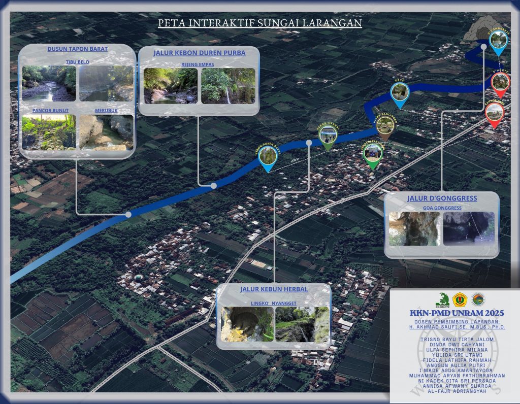
Welcome to Bilebante Green Tourism Village, an ecotourism destination that combines natural beauty and local wisdom. Here, the Larangan River serves as both the lifeblood of the village and a captivating tourist route.
Through the Interactive Map of the Larangan River, you can explore a scenic route that stretches from the headwaters to the mouth, passing through four main sections, each with its own unique charm and character.
- Dusun Tapon Barat, Welcoming you with natural scenery such as Tibu Belo clear, Pancor Bunut unique, and natural rock formations Merubuk.
- Jalur Kebon Duren Purba, A serene atmosphere Rejeng Empas It offers the sensation of exploring a pristine and unspoiled tropical forest.
- Jalur Kebun Herbal, Save Lingko Nyangget, lokasi penuh cerita lokal yang juga menjadi pusat edukasi tanaman herbal.
- Jalur D’Gonggress, Wrapping up the trip with Goa Gonggress, a natural cave that exudes an aura of mystery and geological beauty
This map is not just a travel guide, but also an invitation to experience an adventure that blends nature, culture, and environmental education. By using this interactive map, every step becomes more purposeful, safer, and full of stories.
The Larangan River: Between Myths, Academic Perspectives, and Sustainability
When it comes to rivers, Indonesia is truly a place with endless natural beauty and a wide variety of unique natural features—one of which is its rivers. But did you know that in Indonesia—specifically in Bilebante Village, Central Lombok—there’s actually a river called the Larangan River? Why is it called the Larangan River? Wait a minute—before we dive deeper into why it’s named the Larangan River, let’s flashback Let’s take a trip back in time and talk about the Larangan River, starting from its very beginnings.
Well, before this river was named “Sungai Larangan,” the residents of Bilebante Village had their own name for it. They usually called it “Kokoq Babak.” Why was the river named “Kokoq Babak”? Well, the name originated from the fact that villagers who went to play or walk along the river often slipped, causing some of them to get scrapes on their bodies. The Sasak word for “scrape” is “babak,” so eventually, because of these incidents, the river came to be known as “Kokoq Babak.” But, friends, “Kokoq Babak” didn’t just appear out of nowhere. It was formed as a result of two natural events. What were they? Let’s discuss them together.
- To sum it up, friends, based on interviews conducted with several informants, according to the knowledge passed down by the older generation, this river was formed by the flow from the crater of Mount Rinjani, which erupted decades ago, carrying a massive volume of sandy water. In fact, there used to be a dam there where the flow deposited large piles of sand. As a result of this crater flow, the area in the village of Bilebante was filled with a lot of sand, and it actually became a sand mining site. Did you know, friends? Before this sand deposit was mined, it was even higher than the road. After excavation, the sand dune became more contoured and its elevation dropped below that of the highway. So, this area has actually existed for a long time, and our ancestors referred to it as the dividing line between Central Lombok and West Lombok, since it’s situated right in the middle of those two regencies. It turns out this place holds a wealth of charm as well as unsolved mysteries that haven’t been widely discussed by the general public.
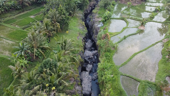
- Second, friends, the reason this river has become wider is due to natural seismic activity. These earthquakes caused cracks in the rock, forming cliffs and creating a more beautiful river flow—the Kokoq Babak—with a distinctive shape. As a result of these earthquakes, the Kokoq Babak has sections with cracks known as “rejeng empas,” and these are found in three areas. Want to know why it’s called “rejeng empas”? What’s the connection to the earthquake? Well, during the earthquake, there were several spots along the Kokoq Babak River where the rocks shattered or fell (known in the Sasak language as “empes” or “empas”). That’s the origin of the name “rejeng empas.” Okay, within Rejeng Empas, there are also specific spots with different names, and of course, each has its own unique characteristics. In the western part of Rejeng Empas, there’s an area called Tebu Belo, and further west, the area is named Merubek and Batu Melase because the rock in the center—surrounded by other rocks—is flat.
Well, we already know why the Larangan River is better known as Kokoq Babak. Now I want to ask you something By the way, have you ever heard of the Larangan River? When you hear the word “larangan,” you probably immediately start thinking all sorts of strange things, right? What exactly is forbidden there? And why is it called “Larangan”? Instead of letting your curiosity grow, let’s discuss it together and get to know the Larangan River a little better. Who knows—after reading this, you might want to head straight there to see its beauty and hear its stories for yourself. Let’s jump right into the next section!
The Larangan River is actually more than just an ordinary river. There are so many stories to uncover here. We can start by exploring the fascinating history of the river’s formation, then delve into the many tales passed down by the local community, and finally examine the unique natural rocks found along its banks. Speaking of history, there are surely many hidden stories and long-standing tales about this river that aren’t widely known by the public. It’s said that the name “Larangan” was originally proposed by the POKDARWIS organization and academic figures due to several existing issues. The word “Larangan” was chosen as the river’s name to encourage the community to care more about their surroundings, especially since this river serves as a habitat for a wide variety of flora and fauna. Thus, the name “Larangan” emerged from an initiative to prevent people from exploiting the river’s natural resources and to urge them to properly preserve the river’s ecosystem.
But here’s the thing, friends: the reason this river is called “Larangan” isn’t just from an academic perspective, but also from other angles—including the unwritten rules (awik-awik) for visiting the river. Want to know the other reasons why this river is called “Larangan”? Let’s move on to the next part of the discussion…
A Story from Kokoq Babak/Sungai Larangan: A Serene River That Holds Mysteries
So, friends, behind its seemingly calm waters, the Larangan River actually holds a story that isn’t widely known by the general public. According to old tales, this beautiful place shouldn’t be taken lightly—especially at certain times and under certain conditions. They say that if you visit when your mind is unfocused or your body isn’t in good shape, you’re very likely to be “disturbed.” I wonder who “disturbs” us? It’s definitely the river’s guardian, right? So, during your visit, friends, we’re asked to always be mindful of our behavior so that our presence doesn’t disturb the other beings living there.
A while back, there was a newcomer to the area who went swimming in the Larangan River when the water was at its calmest. At first, everything seemed normal, until suddenly a whirlpool appeared and dragged him toward the middle of the river. Luckily, his friend quickly pulled him out, and he survived. Ever since that incident, that person has never wanted to go back to that river. Trauma, they said. That’s an understandable reason, since it’s truly dangerous. As for the specific taboo regarding women, it pertains to menstruation. The community advises that women should avoid going to the river while menstruating. They say that during that time, women are more vulnerable to disturbances from spirits, which is why it’s also recommended not to just show up at places like that. This isn’t just a myth, but part of local wisdom that has been passed down through generations.
Several other incidents that were just as terrifying have occurred in the Larangan River, you know. Some people were swept away after slipping, while others died because the river’s current was at its strongest. In fact, one victim was even found in the western part of Kediri (Gelogor) after being swept away by the river’s current. There was also a resident from the Pemepek area who fell in and was found lifeless in the western section of the river. All these incidents serve as a reminder that nature is indeed beautiful, but it must still be respected and treated with caution. Stories like these aren’t meant to scare anyone, but rather to remind us to always be mindful and more aware of our surroundings. Sometimes, what we can’t see is precisely what deserves our greatest respect. And because this river has been shaped by natural events for decades, it has become a priceless natural heritage—so we must take good care of this legacy as a way of honoring its existence.
So, friends, it turns out that the Larangan River is viewed from two different perspectives, yet they form a single, interconnected whole. So, in light of everything that has happened and the existing taboos, we are actually simply asked to appreciate, respect, and preserve our natural heritage, as well as to follow the established customs, so that we can live in harmony with the surrounding environment and all its inhabitants.
More about the Larangan River in the Bilebante Green Tourism Village CLICK HERE!
Interactive Map Created by: